If you are looking for spectacular waterfall hikes near Asheville NC in the western North Carolina Mountains, DuPont State Forest is a winner, with more than a half a dozen waterfalls to hike to, and all within a relatively small area. Many of the hikes are very easy because of the gravel road system throughout parts of the 10,300 Forest acres. Besides hiking, this area is also very popular and friendly for Mountain Bikers and Equestrians, with a network of over 90 miles of trails, from single track to wide gravel roads. The gravel roads are closed to motorized traffic.
Most of the Arena Scenes from the Hunger Games movie were filmed at DuPont State Forest, with film crew taking advantage of the easily accessible creeks and waterfalls for scenes along with the spectacular forest scenes.
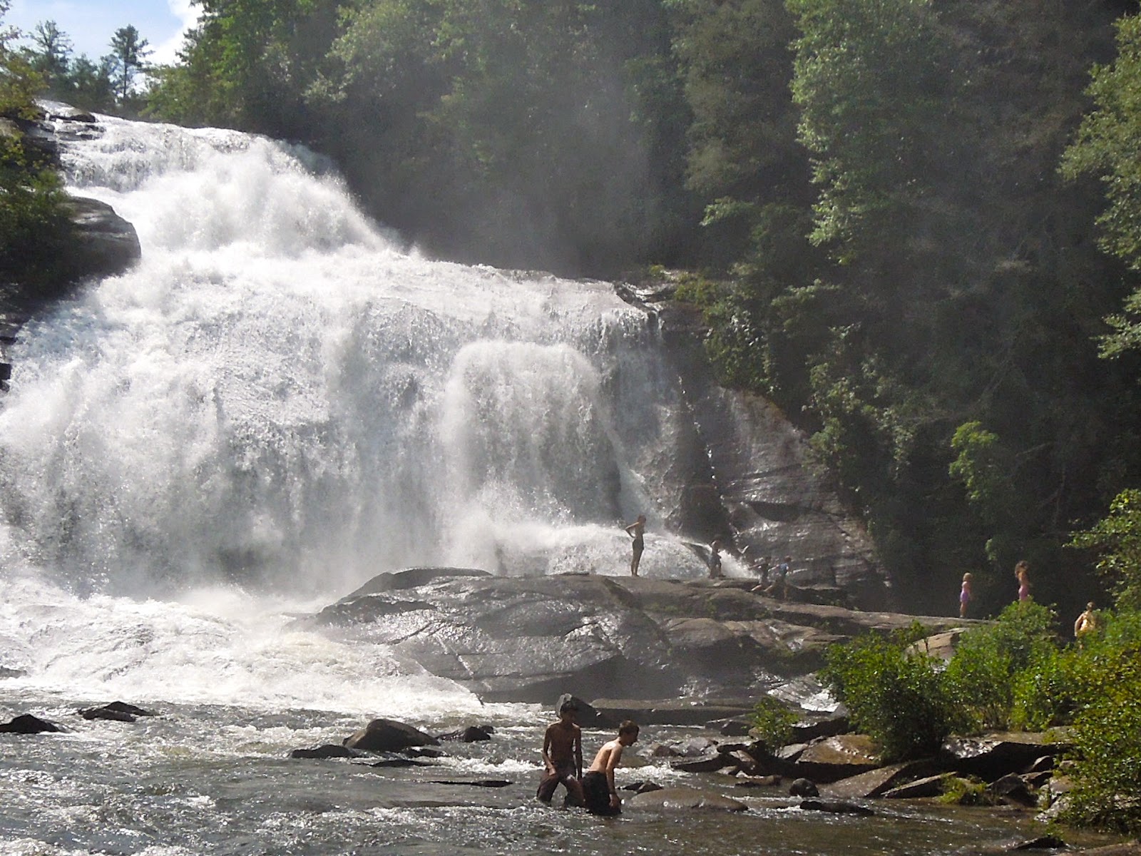 My favorite waterfall is High Falls so the directions and photos here will be mostly about this amazing waterfall. The photo above shows a booming High Falls, just after heavy rains – a great way to cool off on a hot summer day. The mist and breezes from the falls are refreshing
Getting to High Falls and DuPont State Forest from Asheville, NC: Take I-26 East and take Exit #40 at the Asheville Airport. At the end of the ramp, turn right onto NC 280 (the Airport will be immediately on your right). Stay on NC 280 for 16 miles. There will be a major 4 way intersection (fast food, ice-cream, WalMart, grocery store, outdoor shops and outdoorguides may all be found here). At this traffic light and 4-way intersection, turn left onto US 64 and travel 3.7 miles to a traffic light at a Triangle Stop (gas station and quick mart in Penrose). Turn right here onto Crab Creek Road and go 4.3 miles to DuPont Road (old very blue, 2 story building on your right at this turn) and go 4.2 miles on DuPont Road. You will notice that DuPont Road changes names to Staton Road. Go past the Hooker Falls Access (on your right) to the High Falls Access Area which will be a bit further up on your left. There are restrooms at this parking lot. Trails are well marked, there is lots of signage everywhere in DuPont State Forest.
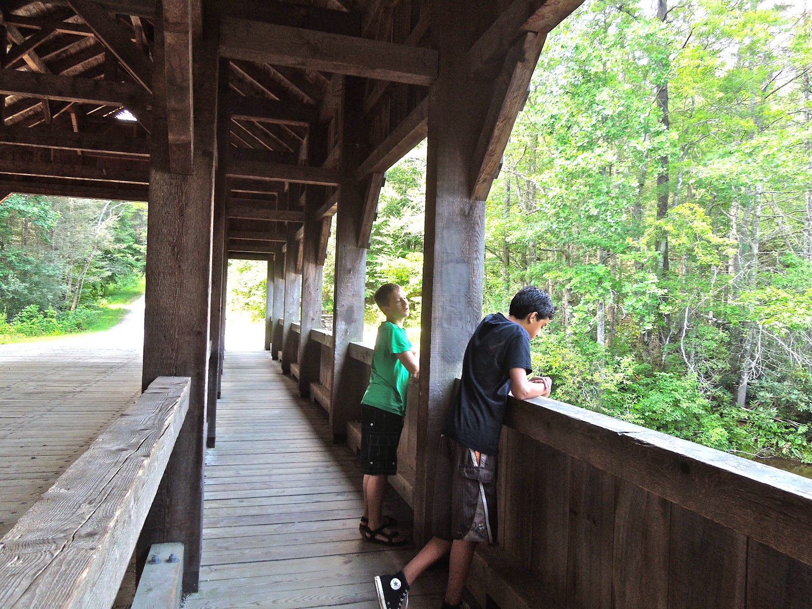
This gravel parking lot is pretty fancy for State Forest parking – the entrance is complete with fancy gates and rock pillars. There is a reason for this – DuPont State Forest land was almost a private, large and exclusive residential development. The developer had the intention of closing all of the trails and waterfalls to the public. Through a series of events and public outcry, the site was acquired by the State in the year 2000, after the North Carolina Council of State, led by Govenor Jim Hunt, voted to invoke its power of eminent domain. Before being seized by the State, many well graded roads and buildings were put into the property by the developer (be sure and visit the Covered Bridge at the top of High Falls, part of the work of the private developer). DuPont State Forest is here for us to enjoy today, and it is indeed always enjoyable to visit and especially appreciated since it was almost lost to the public forever.
High Falls: At the end of the parking lot continue down the gravel road (Buck Forest Road) and follow signs to High Falls. It is about a 15 – 20 minute walk from the parking lot to the base of High Falls, mostly on gravel roads. A well marked left turn will take the trail downward and past two wonderful views of High Falls. The last bit of trail is a sharp right turn into the woods and along the Little River and will end at the base of High Falls. The views will take your breath away.
Many easy side trips are recommended. The High Falls hike may be made into a longer 3 mile loop hike by adding in side trips to Triple and Hooker Falls. Trails to these two falls are well marked along the way.

From High Falls, on your return to the parking lot, turn left at a well marked intersection and add a trip to the Covered Bridge at the top of High Falls. It is not far from this intersection. You can’t see the falls from the vantage point on the bridge, but watching and listening to the powerful drop-off of the river is enjoyable and the bridge will provide shade and usually a breeze. From the Covered Bridge, Grassy Creek Falls is an easy add on hike as well and will likely be much less crowded than the very popular High Falls and Triple Falls areas. After crossing the Covered Bridge, stay on the main gravel road (Buck Forest Road) for about another half mile, passing a right turn for Conservation Road. Once across Grassy Creek, turn left onto Lake Imaging Trail (road) to the marked Grassy Creek Falls trail on the left to the top of the falls. A trail will take you down the creek to the base of the waterfall.
 Easy hiking, multiple falls to see, well graded roads closed to motorized traffic, lots of water, swimming holes, gorgeous scenery, make this a family friendly hike as well as a pet friendly hike. Do be cautious with yourself, children and pets, as deaths occur every year in Western North Carolina due to overconfident and careless hikers at waterfalls.
If you are looking for a place to stay in Asheville, NC, Oakland Cottage B&B is a family friendly bed and breakfast, as well as a pet friendly bed and breakfast. And if you need more private accommodations, Vacation In Asheville can help you with Asheville Cabin Rentals and Asheville Vacation Rentals. The reservation offices are open 9am to 7pm daily and you may reach the very helpful staff at 828 994-2627 during these times.